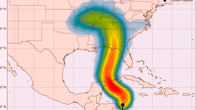
Significant hurricane threat growing for the northeastern Gulf coast
Potential Tropical Cyclone Nine is approaching, with
forecasts placing the northeastern Gulf, including the Florida Panhandle and
Big Bend, on high alert.
A cluster of storms organizing over the western Caribbean,
east of Central America, is expected to develop into a named storm over the
next day or two. It could rapidly intensify into a powerful hurricane as it
tracks toward the northeastern Gulf Coast, impacting areas such as the Florida
Panhandle and Big Bend by late Thursday into early Friday.
Potential
Tropical Cyclone Nine forthcoming
On Monday morning, the National Hurricane Center indicated that watches or
warnings would soon be issued for parts of Mexico's Yucatán Peninsula and
western Cuba. This will trigger a full set of official forecast products,
including the first forecast cone for newly designated Potential Tropical
Cyclone Nine, expected by 11 AM ET.
Reliable intensity models suggest a significant hurricane threat is building
as the strengthening system moves over a warm pool of water in the east-central
Gulf of Mexico by mid-week. There is an increasing likelihood that a major
hurricane (Category 3 or higher) will threaten parts of northern Florida or the
Big Bend region before the end of the work week.
Residents from Mobile to Tampa should closely monitor forecasts throughout
the week. Those along Florida’s entire west coast should also keep an eye on
the storm's path, as even a near miss could bring heavy rainfall and
significant coastal impacts.
If the potential tropical cyclone strengthens as many models predict, its
rapid movement later in the week could cause problems far inland across the
southeastern U.S. Widespread impacts could extend into northern Georgia,
eastern Tennessee, and the Carolinas starting Friday.
The forecast indicates a potentially damaging and impactful week of weather
for the southeastern U.S.
An
environment ripe for strengthening
In the next day or two, we'll be monitoring how quickly the system organizes
and whether it forms a compact core, something recent storms have struggled to
achieve. A consolidated core—marked by a tight wind field and concentrated
storm activity—could trigger rapid intensification as the system moves into the
favorable conditions of the eastern Gulf of Mexico.
The alignment of upper-level winds from a nearby jet stream dip is expected
to support steady to rapid strengthening on Wednesday and Thursday. Our most
reliable high-resolution hurricane models indicate the potential for a
devastating major hurricane heading toward northern Florida.
Forecasting hurricane intensity is always a challenge, but with the
potential for rapid strengthening as the storm nears land, those in its path
should be prepared to activate their hurricane plans and evacuate if advised.
Wet and
windy weather for South Florida
Although South Florida isn't directly threatened by the
developing storm, it will experience peripheral effects, primarily in the form
of extended wet and windy weather starting tomorrow night in the Keys and on
Wednesday in Miami-Dade and Broward counties.
Tropical downpours may continue through Friday, potentially
causing localized flooding, especially later in the week.
No
imminent threats elsewhere across the Atlantic
In the broader Atlantic, a tropical disturbance off the west
coast of Africa is expected to develop by mid to late week over the eastern
Atlantic. However, most models suggest the system will turn into the open ocean
long before approaching the islands.


